


Please use this identifier to cite or link to this item:
http://hdl.handle.net/2307/5550| Title: | Ancoraggio di Mogadiscio | Discipline: | Center for Somali Studies List of Subjects::Geography::cartography Xoghayaha Xarunta Cilmibaarista Soomaaliyeed::Juqraafi::khariiqad samayn Soggettario Centro Studi Somalo::GEOGRAFIA::Cartografia |
Keywords: | map Mogadishu districts khariidad Mudisho degmooyin cartina Mogadiscio quartieri |
Issue Date: | 12-Dec-2016 | Type: | Image | Call Number: | Originale conservato presso il Centro studi Somali : http://host.uniroma3.it/centri/CentroStudiSomali/index.php | Image Subject: | Writings on the left: "Indian Ocean - Italian Somalia. Mogadishu's anchoring. Original surveys by the royal ship 'Staffetta', 1911, and other following surveys until 1934". The two areas with irregular streets are Xamar Weyne (bottom left) and Shangani (top right). (The areas of the map labelled Amaruini and Scingani have been mis-identified as Xamar Weyne and Shangani). These area of settlement date back to the 9-10th century AD. The straight and wider streets were developed by the Italian colonial administration between 1900 and 1934. The Italian built railway line is visible on the top. It went from the port near Abdul Aziz, out to Afgoye on the Shebelli river. Dhanka sare ee bidix waxaa ku qoran "Oceano Indiano - Somalia Italiana. Ancoraggio di Mogadiscio. Rilievi originali della Regia nave 'Staffetta' 1911 e da quelli successivi fino al 1934". Labada bed ee waddadooyinkoodu aan toosanayn waa xaafadaha Xamar Weyn (dhanka hoose ee bidix) iyo Shangaani (dhanka sare ee midig). Labadan xaafadadood waxaa la degay qarnigii 9aad-10aad M.k.d. Jidadka toosan ee ballaaran waxaa sameeyay maamulkii gumaysiga Talyaaniga muddada u dhexeysay 1900 ilaa 1934. Qaybta sare waxaa kaloo laga arkayaa waddo tareen oo la sameeyey isla waqtigaas, waxayna ka billaabmaaysaa agagaarka xaafadda Cabdulcasiis ilaa Afgooy, webiga Shabellee korkiisa. In alto a sinistra si legge: "Oceano Indiano - Somalia Italiana. Ancoraggio di Mogadiscio. Rilievi originali della Regia nave 'Staffetta' 1911 e da quelli successivi fino al 1934". Le due aree con strade irregolari sono i quartieri Xamar Weyne (in basso a sinistra) e Shangani (in alto a destra), le aree della mappa indicate (nel primo caso erroneamente) come Amaruini e Scingani. Questi insediamenti risalgono al IX-X secolo d.C. Le strade diritte e larghe sono opera dell'amministrazione coloniale italiana che le ha costruite tra il 1900 e il 1934. In alto, è visibile anche la ferrovia, opera dello stesso periodo, che andava dal porto vicino Abdul Aziz fino ad Afgoi, sul fiume Scebeli. Link: https://mogadishuimages.wordpress.com/2008/05/09/mogadishu-in-1934/ |
Description: | Image taken from the website "Mogadishu: Images from the past" (https://mogadishuimages.wordpress.com/) and included in the Somali Archive with the permission of the owner of the collection, Mr. Davies. Sawirkan waxaa laga soo qaatay mareegta "Mogadishu: " (https://mogadishuimages.wordpress.com/) waxaana lagu biiriyay Kaydka Soomaaliya, kaddib markii ruqsad laga helay milkiilaha, Mr. Davies. Immagine tratta dal sito "Mogadishu: Images from the past" (https://mogadishuimages.wordpress.com/) e inclusa nell'Archivio Somalia con il consenso del curatore della collezione Rick Davies. |
Location: | Mogadiscio | URI: | http://hdl.handle.net/2307/5550 | Language: | it |
| Appears in Collections: | Immagini - Sawirro - Images |
Files in This Item:
| File | Description | Size | Format | |
|---|---|---|---|---|
| 205_1911map1.gif | 251.37 kB | GIF | 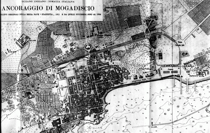 View/Open |
Page view(s)
385
checked on Jul 6, 2026
Download(s)
169
checked on Jul 6, 2026

Google ScholarTM
Check
This item is licensed under a Creative Commons License
