


Please use this identifier to cite or link to this item:
http://hdl.handle.net/2307/5523| Title: | Mogadishu, circa 1740 | Discipline: | Center for Somali Studies List of Subjects::Geography::cartography Xoghayaha Xarunta Cilmibaarista Soomaaliyeed::Juqraafi::khariiqad samayn Soggettario Centro Studi Somalo::GEOGRAFIA::Cartografia |
Keywords: | geographical map cartography 1700 khariidad Mudisho carta geografica cartografia |
Issue Date: | 7-Dec-2016 | Type: | Image | Call Number: | Originale conservato presso il Centro studi Somali : http://host.uniroma3.it/centri/CentroStudiSomali/index.php | Image Subject: | Magadoxo (Mogadishu) is visible on the southern end of the east African coastline. The map was published in Antoine-François Prevosts monumentus 20 volume edition of L'Histoire Générale des Voyages published by Pierre de Hondt, The Hague in 1747. The mapmaker: Jacques Nicholas Bellin 1703-72. Bellin spent over fifty years at the French Hydrographic Service where he was appointed the first "Ingenieur hydrographe de la Marine". During his term of office there, he was commissioned to carry out major surveys, first of the coast of France and later of all the known coasts of the world. These tremendous undertakings resulted in the production of a very large number of sea charts of the highest quality, which appeared in many editions with varying numbers of charts to the end of the century. He was appointed Hydrographer to the King and was a member of the Royal society in London. Magaca Mogadixo (Muqdisho) wuxuu ka muuqdaa qaybta hoose ee xeebta Afrikada bari. Khariiddadan waxaa lagu daabacay "Antoine-François Prevosts monumentus" 20 volume tifaftiraha "L'Histoire Générale des Voyages" waxaa daabacay Pierre de Hondt, The Hague in 1747. The mapmaker: Jacques Nicholas Bellin 1703-72. Bellin muddo 50 sano ayuu ka shaqaynaayay "the French Hydrographic Service" waxaana lagu magacaabay markii ugu hrreeyay "Ingenieur hydrographe de la Marine". Xilligaas waxaa loo xilsaaray in uu baaro, marka hore xeebta Fransiiska, kaddibna xeebaha kale ee dunida. Wuxuuna xibin ka noqday "the Royal society in London". Magadoxo (Mogadiscio) si vede all'estremità meridionale della costa orientale africana. La mappa è stata pubblicata in "L'Histoire Générale des Voyages" di Antoine-François Prevosts edita da Pierre de Hondt, L'Aia nel 1747. L'autore della mappa è Jacques Nicholas Bellin (1703-1772), Bellin rimase al servizio del French Hydrographic Service per più di cinquant'anni e venne nominato anche primo "Ingegnere idrografo della Marina". Durante il suo servizio, fu incaricato di effettuare diverse indagini importanti, prima della costa francese e successivamente di tutte le coste conosciute del mondo. Questi incarichi imponenti si tradussero nella produzione di un numero considerevole di carte nautiche di elevata qualità, carte apparse in diverse edizioni fino alla fine del secolo. Venne nominato Idrografo del Re ed è stato membro della Royal Society di Londra. Link: https://mogadishuimages.wordpress.com/2008/01/17/mogadishu-in-1770/ |
Description: | Image taken from the website "Mogadishu: Images from the past" (https://mogadishuimages.wordpress.com/) and included in the Somali Archive with the permission of the owner of the collection, Mr. Davies. Sawirkan waxaa laga soo qaatay mareegta "Mogadishu: Images from the past" (https://mogadishuimages.wordpress.com/) waxaan lagu biiriyay Kaydka Soomaaliya kaddib markii laga helay ruqsad Mr. Davies. Immagine tratta dal sito "Mogadishu: Images from the past" (https://mogadishuimages.wordpress.com/) e inclusa nell'Archivio Somalia con il consenso del curatore della collezione Rick Davies. |
URI: | http://hdl.handle.net/2307/5523 |
| Appears in Collections: | Immagini - Sawirro - Images |
Files in This Item:
| File | Description | Size | Format | |
|---|---|---|---|---|
| 208_Mogadishu_ circa 1740.jpg | 63.97 kB | JPEG | 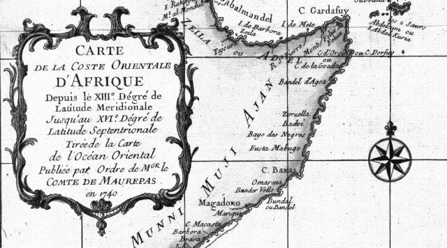 View/Open |
Page view(s)
270
checked on Jul 12, 2026
Download(s)
56
checked on Jul 12, 2026

Google ScholarTM
Check
This item is licensed under a Creative Commons License
