


Please use this identifier to cite or link to this item:
http://hdl.handle.net/2307/5583| DC Field | Value | Language |
|---|---|---|
| dc.coverage.spatial | Mogadiscio | en_US |
| dc.date.accessioned | 2016-12-20T11:20:19Z | - |
| dc.date.available | 2016-12-20T11:20:19Z | - |
| dc.date.issued | 1938 | - |
| dc.identifier.uri | http://hdl.handle.net/2307/5583 | - |
| dc.description | Image taken from the website "Mogadishu: Images from the past" (https://mogadishuimages.wordpress.com/) and included in the Somali Archive with the permission of the owner of the collection, Mr. Davies. | en_US |
| dc.description | Sawir laga soo qaatay mareegta "Mogadishu: Images from the past" (https://mogadishuimages.wordpress.com/) waxaa lagu biiriyay Kaydka Soomaaliya, kaddib markii laga helay ruqsad milkiilaha sawirrada, Mr. Davies. | en_US |
| dc.description | Immagine tratta dal sito "Mogadishu: Images from the past" (https://mogadishuimages.wordpress.com/) e inclusa nell'Archivio Somalia con il consenso del curatore della collezione Rick Davies. | en_US |
| dc.subject | Mogadiscio | en_US |
| dc.subject | mappa | en_US |
| dc.subject | Muqdisho | en_US |
| dc.subject | khariidad | en_US |
| dc.subject | Mogadishu | en_US |
| dc.subject | maps | en_US |
| dc.title | Mogadishu map, 1986 | en_US |
| dc.type | Image | en_US |
| dc.relation.altloc | Originale conservato presso il Centro studi Somali : http://host.uniroma3.it/centri/CentroStudiSomali/index.php | |
| dc.subject.studisomali | ::Center for Somali Studies List of Subjects::Geography::cartography | en_US |
| dc.subject.studisomali | ::Xoghayaha Xarunta Cilmibaarista Soomaaliyeed::Juqraafi::khariiqad samayn | en_US |
| dc.subject.studisomali | ::Soggettario Centro Studi Somalo::GEOGRAFIA::Cartografia | en_US |
| dc.description.subject | Produced as a folding map to go with “Mogadishu from the Air”, produced by USAID. City centre was enlarged as a separate smaller map, shown below. Numbers are explained at the top of the laerger map above. | en_US |
| dc.description.subject | Khariiddad laysku laabi karo, oo ku lifaaqan qoraalka "Mogadishu from the air", waxaana soo saaray USAID. Bartamaha magaalada oo si gaar ah loo weyneeyay ayaa lagu sawiray khariiddad yar oo gaar ah. | en_US |
| dc.description.subject | Mappa pieghevole allegata alla pubblicazione "Mogadishu from the air", prodotto da USAID. Il centro città è stato riprodotto ingrandito rispetto alla mappa in una cartina più piccola, separata. La legenda si trova sulla mappa più grande. | en_US |
| dc.description.subject | Link: https://mogadishuimages.wordpress.com/2013/04/07/mogadishu-map-1986/ | en_US |
| item.grantfulltext | open | - |
| item.fulltext | With Fulltext | - |
| Appears in Collections: | Immagini - Sawirro - Images | |
Files in This Item:
| File | Description | Size | Format | |
|---|---|---|---|---|
| 077b_citycentremap.jpg | 37.55 kB | JPEG | 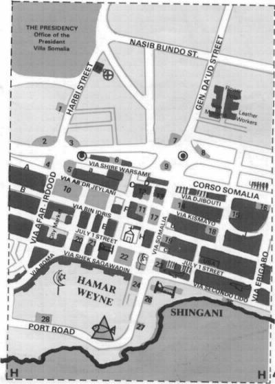 View/Open | |
| 077a_wholemog4.jpg | 36.11 kB | JPEG |  View/Open |
Page view(s)
472
Last Week
2
2
Last month
11
11
checked on Jul 19, 2026
Download(s)
362
checked on Jul 19, 2026

Google ScholarTM
Check
This item is licensed under a Creative Commons License
