


Adeegso tilmaantan si aad u carrabbaabdo ama ugu samayso link qoraalkan
http://hdl.handle.net/2307/5553| Bed DC | Qiimo | Luqad |
|---|---|---|
| dc.coverage.spatial | Mogadiscio | it_IT |
| dc.date.accessioned | 2016-12-12T09:47:37Z | - |
| dc.date.available | 2016-12-12T09:47:37Z | - |
| dc.date.issued | 2016-12-12 | - |
| dc.identifier.uri | http://hdl.handle.net/2307/5553 | - |
| dc.description | Image taken from the website "Mogadishu: Images from the past" (https://mogadishuimages.wordpress.com/) and included in the Somali Archive with the permission of the owner of the collection, Mr. Davies. | it_IT |
| dc.description | Sawir laga soo qaatay mareegta "Mogadishu: Images from the past" (https://mogadishuimages.wordpress.com/), waxaana lagu biiriyay Kaydka Soomaaliya, kaddib markii oggolaasho laga helay qofka diyaariyay oo ah Rick Davies. | it_IT |
| dc.description | Immagine tratta dal sito "Mogadishu: Images from the past" (https://mogadishuimages.wordpress.com/) e inclusa nell'Archivio Somalia con il consenso del curatore della collezione Rick Davies. | it_IT |
| dc.subject | geographical map | it_IT |
| dc.subject | Mogadishu | it_IT |
| dc.subject | districts | it_IT |
| dc.subject | khariidad | it_IT |
| dc.subject | Muqdisho | it_IT |
| dc.subject | degmooyin | it_IT |
| dc.subject | cartina geografica | it_IT |
| dc.subject | Mogadiscio | it_IT |
| dc.subject | quartieri | it_IT |
| dc.title | Mogadishu, circa 1889 | it_IT |
| dc.type | Image | it_IT |
| dc.relation.altloc | Originale conservato presso il Centro studi Somali : http://host.uniroma3.it/centri/CentroStudiSomali/index.php | |
| dc.subject.studisomali | Center for Somali Studies List of Subjects::Geography::cartography | it_IT |
| dc.subject.studisomali | Xoghayaha Xarunta Cilmibaarista Soomaaliyeed::Juqraafi::khariiqad samayn | it_IT |
| dc.subject.studisomali | Soggettario Centro Studi Somalo::GEOGRAFIA::Cartografia | it_IT |
| dc.description.subject | Map of Mogadishu circa 1889. "Tour" is the minaret near the Abdul Aziz mosque. In the middle of "Hamarouin" (Xamar Weyne) another tower is visible but unnamed (the circle sorrounded by "Hamarouin"). That tower still existed in the 1980’s. Bimal and Arcal (Abgal) are Somali clan names. The map comes from "The Earth and its Inhabitants: Africa (South and East Africa)", authored by Élisée Reclus and published by the D. Appleton and Company in 1889. | it_IT |
| dc.description.subject | Khariiddo Muqdisho, oo waqtigeeda lagu qiyaasay 1889. "Tour" waa minaaradda ku tiil masjidka Abdul Aziz agtiisa. Bartamaha "Hamarouin" (Xamar Weyne) waxaa lagu arki karaa minaarad kale, oo aan magaceeda ku xusnayn halkaas. Minaaraddaas waxay jiri jirtay ilaa 80meeyadii. Bimal iyo Arcal (Abgal) ayaa labada dhinac kala degganaa. Raadraaca khariiddada: "The Earth and its Inhabitants: Africa (South and East Africa)", Élisée Reclus, D. Appleton and Company, 1889. | it_IT |
| dc.description.subject | Mappa di Mogadiscio, 1889 ca. "Tour" corrisponde al minareto vicino la moschea Abdul Aziz. Al centro di "Hamarouin" (Xamar Weyne) è visibile un'altra torre il cui nome non è indicato. Quella torre esisteva ancora negli anni '80. Bimal e Arcal (Abgal) sono nomi di due clan somali. La mappa è tratta dal volume "The Earth and its Inhabitants: Africa (South and East Africa" di Élisée Reclus, pubblicato nel 1889 da D. Appleton and Company. | it_IT |
| dc.description.subject | Link: https://mogadishuimages.wordpress.com/2008/05/09/map-of-mogadishu-circa-1889/ | it_IT |
| item.fulltext | With Fulltext | - |
| item.grantfulltext | open | - |
| Wuxuu ka dhex muuqdaa ururinnada: | Immagini - Sawirro - Images | |
Fayl ku dhex jira qoraalkan:
| Fayl | Sifayn | Baac | Fayl | |
|---|---|---|---|---|
| 206_1894mogmap.jpg | 82.75 kB | JPEG | 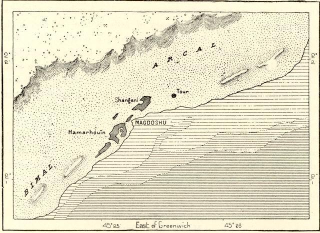 Muuji/fur |
Page view(s)
479
checked on Jul 12, 2026
Download(s)
100
checked on Jul 12, 2026

Google ScholarTM
Check
Qoraalkan wuxuu u habaysanyahay si waafaqsan Ruqsada Creative Commons
