


Please use this identifier to cite or link to this item:
http://hdl.handle.net/2307/5474| DC Field | Value | Language |
|---|---|---|
| dc.coverage.spatial | Berbera | it_IT |
| dc.date.accessioned | 2016-11-28T09:24:32Z | - |
| dc.date.available | 2016-11-28T09:24:32Z | - |
| dc.date.issued | 1889 | - |
| dc.identifier.uri | http://hdl.handle.net/2307/5474 | - |
| dc.description | "Mogadishu: Images from the past" (https://mogadishuimages.wordpress.com/) and included in the Somali Archive with the permission of the owner of the collection, Mr. Davies. | it_IT |
| dc.description | Sawir laga soo qaatay mareegta "Mogadishu: Images from the past" (https://mogadishuimages.wordpress.com/), waxaana lagu biiriyay Kaydka Soomaaliya, kaddib markii oggolaasho laga helay qofka diyaariyay oo ah Rick Davies. | it_IT |
| dc.description | Immagine tratta dal sito "Mogadishu: Images from the past" (https://mogadishuimages.wordpress.com/) e inclusa nell'Archivio Somalia con il consenso del curatore della collezione Rick Davies. | it_IT |
| dc.subject | Berbera | it_IT |
| dc.subject | mappa | it_IT |
| dc.subject | Barbara | it_IT |
| dc.subject | khariidad | it_IT |
| dc.subject | Berbera | it_IT |
| dc.subject | map | it_IT |
| dc.title | Berbera, circa 1889 | it_IT |
| dc.type | Image | it_IT |
| dc.relation.altloc | Originale conservato presso il Centro studi Somali : http://host.uniroma3.it/centri/CentroStudiSomali/index.php | |
| dc.subject.studisomali | Soggettario Centro Studi Somalo::GEOGRAFIA::Cartografia | it_IT |
| dc.subject.studisomali | Xoghayaha Xarunta Cilmibaarista Soomaaliyeed::Juqraafi::khariiqad samayn | it_IT |
| dc.subject.studisomali | Center for Somali Studies List of Subjects::Geography::cartography | it_IT |
| dc.description.subject | Mappa della città di Berbera pubblicata nel 1889. La mappa è tratta da pp. 413-414 di "The Earth and its Inhabitants: Africa (South and East Africa)” di Élisée Reclus e pubblicato da D. Appleton and Company. | it_IT |
| dc.description.subject | Khariiddada magaalada Barbara oo la dabaacay 1889. Waxaa khariiddadan oo laga soo qaatay bogagga 413-414 ee qoraalka "The Earth and its Inhabitants: Africa (South and East Africa", Élisée Reclus, waxaa daabacay D. Appleton and Company. | it_IT |
| dc.description.subject | Map of city of Berbera published in 1889. The map comes from page 413-414 of "The Earth and its Inhabitants: Africa (South and East Africa)”, authored by Élisée Reclus and published by the D. Appleton and Company. | it_IT |
| dc.description.subject | Link: https://mogadishuimages.wordpress.com/2014/01/03/berbera-circa-1889/ | it_IT |
| item.grantfulltext | open | - |
| item.fulltext | With Fulltext | - |
| Appears in Collections: | Immagini - Sawirro - Images | |
Files in This Item:
| File | Description | Size | Format | |
|---|---|---|---|---|
| 051_berbera.jpg | 44.26 kB | JPEG | 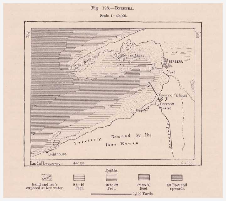 View/Open |
Page view(s)
883
Last Week
0
0
Last month
9
9
checked on Aug 1, 2026
Download(s)
162
checked on Aug 1, 2026

Google ScholarTM
Check
This item is licensed under a Creative Commons License
