


Please use this identifier to cite or link to this item:
http://hdl.handle.net/2307/5471| DC Field | Value | Language |
|---|---|---|
| dc.date.accessioned | 2016-11-28T09:16:03Z | - |
| dc.date.available | 2016-11-28T09:16:03Z | - |
| dc.date.issued | 1857 | - |
| dc.identifier.uri | http://hdl.handle.net/2307/5471 | - |
| dc.description | Tratto da “Karte der Somali – Kuste und des Golf’s von Aden. Th. von Heuglin’s Reise, September bis December 1857”. Immagine tratta dal sito "Mogadishu: Images from the past" (https://mogadishuimages.wordpress.com/) e inclusa nell'Archivio Somalia con il consenso del curatore della collezione Rick Davies. | it_IT |
| dc.description | Raadraaca: “Karte der Somali – Kuste und des Golf’s von Aden. Th. von Heuglin’s Reise, September bis December 1857”. Sawir laga soo qaatay mareegta "Mogadishu: Images from the past" (https://mogadishuimages.wordpress.com/), waxaana lagu biiriyay Kaydka Soomaaliya, kaddib markii oggolaasho laga helay qofka diyaariyay oo ah Rick Davies. | it_IT |
| dc.description | From “Karte der Somali – Kuste und des Golf’s von Aden. Th. von Heuglin’s Reise, September bis December 1857”. Image taken from the website "Mogadishu: Images from the past" (https://mogadishuimages.wordpress.com/) and included in the Somali Archive with the permission of the owner of the collection, Mr. Davies. | it_IT |
| dc.subject | mappa | it_IT |
| dc.subject | khariidad | it_IT |
| dc.subject | map | it_IT |
| dc.title | North coast of Somalia, circa 1857 | it_IT |
| dc.type | Image | it_IT |
| dc.relation.altloc | Originale conservato presso il Centro studi Somali : http://host.uniroma3.it/centri/CentroStudiSomali/index.php | |
| dc.subject.studisomali | Soggettario Centro Studi Somalo::GEOGRAFIA::Cartografia | it_IT |
| dc.subject.studisomali | Xoghayaha Xarunta Cilmibaarista Soomaaliyeed::Juqraafi::khariiqad samayn | it_IT |
| dc.subject.studisomali | Center for Somali Studies List of Subjects::Geography::cartography | it_IT |
| dc.description.subject | Mappa della costa settentrionale della Somalia databile 1857. | it_IT |
| dc.description.subject | Khariiddada xeebta woqooyi Soomaaliya, 1857. | it_IT |
| dc.description.subject | Map of northern coast of Somalia datable in 1857. | it_IT |
| dc.description.subject | Link: https://mogadishuimages.wordpress.com/2014/01/03/north-coast-of-somalia-circa-1857/ | it_IT |
| item.fulltext | With Fulltext | - |
| item.grantfulltext | open | - |
| Appears in Collections: | Immagini - Sawirro - Images | |
Files in This Item:
| File | Description | Size | Format | |
|---|---|---|---|---|
| 048_aden_gulf_1860 (1).jpg | 121.48 kB | JPEG | 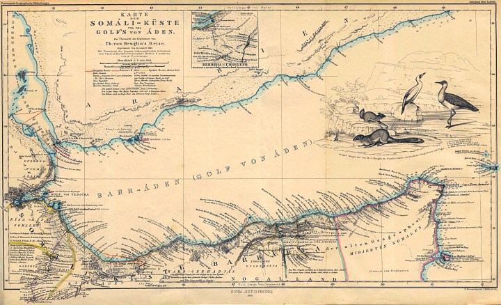 View/Open |
Page view(s)
1,020
Last Week
0
0
Last month
7
7
checked on Jul 11, 2026
Download(s)
205
checked on Jul 11, 2026

Google ScholarTM
Check
This item is licensed under a Creative Commons License
