


Utilizza questo identificativo per citare o creare un link a questo documento:
http://hdl.handle.net/2307/5443| Campo DC | Valore | Lingua |
|---|---|---|
| dc.coverage.spatial | Bender Khor | it_IT |
| dc.date.accessioned | 2016-11-18T09:04:30Z | - |
| dc.date.available | 2016-11-18T09:04:30Z | - |
| dc.date.issued | 2016-11-18 | - |
| dc.identifier.uri | http://hdl.handle.net/2307/5443 | - |
| dc.description | G. Revoil, Voyage au pays des Medjourtaines (Cap Gardufui – Afrique Orientale), pages 254-269, Bulletin de la Societe de Geographie, Mars 1880. | it_IT |
| dc.description | Image taken from the website "Mogadishu: Images from the past" (https://mogadishuimages.wordpress.com/) and included in the Somali Archive with the permission of the owner of the collection, Mr. Davies. | it_IT |
| dc.description | Sawir laga soo qaatay "Mogadishu: Images from the past" (https://mogadishuimages.wordpress.com/) waxaan lagu biiriyaya Kaydka Soomaaliyeed, kaddib markii ruqsad laga helay ururiyaha dokumentooyinka,Rick Davies. | it_IT |
| dc.description | Immagine tratta dal sito "Mogadishu: Images from the past" (https://mogadishuimages.wordpress.com/) e inclusa nell'Archivio Somalia con il consenso del curatore della collezione Rick Davies. | it_IT |
| dc.subject | aerial photographs | it_IT |
| dc.subject | Bender Khor | it_IT |
| dc.subject | sawirro dusha sare laga soo sawiray | it_IT |
| dc.subject | Bandar Khoor | it_IT |
| dc.subject | fotografia aerea | it_IT |
| dc.subject | Bender Khor | it_IT |
| dc.title | Qandala and Botiala | it_IT |
| dc.type | Image | it_IT |
| dc.relation.altloc | Originale conservato presso il Centro studi Somali : http://host.uniroma3.it/centri/CentroStudiSomali/index.php | |
| dc.subject.studisomali | Center for Somali Studies List of Subjects::Archaeology and history::colonial | it_IT |
| dc.subject.studisomali | Xoghayaha Xarunta Cilmibaarista Soomaaliyeed::Arkiyooloji iyo taariikh::xillaga gumaysiga | it_IT |
| dc.subject.studisomali | Soggettario Centro Studi Somalo::ARCHEOLOGIA E STORIA::Coloniale | it_IT |
| dc.description.subject | First image: It is a drawing of the town as seen from the sea. One of the two taller buildings could still be seen in 1991. Second image: The map shows Qandala in relation to Bender Khor, also labeled Boutiala. Boutiala/Botiala is a site of some antiquity. This city is about six miles from the coast , on an island formed by the two arms of dried up Khori , a stream which pours into the sea through narrow and steep gorges. The sea arrives into these gorges, washes to the first huts of the city, maintaining a depth around 5 to 6 cubits or doudouns, which allows small sambucos or dhows to come loaded with mechandises to Bender Khor . Bender Khor is unquestionably the city where the traveller may be the best at what he has before his eyes , refer to the first era of civilization of the people. Four adobe forts guard the gorge, complete with all defence accessories. The cemetery is placed right in the middle of the village and from the mosque, the huts scattered symmetrically under the protection of the forts: …… , contributed to this locality trapped in a huge amphitheatre and a great character that strikes the attention. Here is his drawing of the town of Bender Khor. | it_IT |
| dc.description.subject | Sawirka kowaad: sawirku waa sawirgacmeed magaala laga eegayo dhanka badda. Mid ka mid ah daaraha ugu dhaadheer oo taagnaa ilaa 1991dii. Sawirka 2aad: waa khariiddadii Qandala oo xiriir la leh Bender Khor, oo sidoo kale loo yaqaan Batalaale oo ah rug qaddiim ah. Magaaladu waxay badda u jirtaa qiyaastii 6 mile. Sawirka 3aad: Bender Khor oo oo ka muuqata in ay ka mid tahay magaalooyinka ug facweyn ee Soomaaliya. | it_IT |
| dc.description.subject | Prima immagine: L'immagine è il disegno di una città vista dal mare. Uno degli edifici più alti era ancora in piedi nel 1991. Seconda immagine: la mappa mostra Qandala in relazione a Bender Khor, anche nota come Boutiala. Boutiala/Botiala è un sito antico. La città è a circa sei miglia dalla costa, su un'isola. Il mare arriva nelle gole della costa e bagna le prime capanne della città mantenendo una profondità di 5 o 6 cubiti, che permettono ai piccoli sambuchi (imbarcazione) di commerciare con Bender Khor. Terza immagine: Bender Khor è indubbiamente la città dove i viaggiatori hanno davanti ai loro occhi un esempio della prima era della civiltà somala. Quattro forti sono a guardia della gola. Il cimitero si trova proprio nel centro del paese e dalla moschea , e di un gruppo di capanne sparse simmetricamente sotto la protezione dei forti. | it_IT |
| dc.description.subject | Link: https://mogadishuimages.wordpress.com/2014/01/09/botiala-ruins-near-qandala/ | it_IT |
| item.fulltext | With Fulltext | - |
| item.grantfulltext | open | - |
| È visualizzato nelle collezioni: | Immagini - Sawirro - Images | |
File in questo documento:
| File | Descrizione | Dimensioni | Formato | |
|---|---|---|---|---|
| 037c_bender-khor1.jpg | 316.37 kB | JPEG | 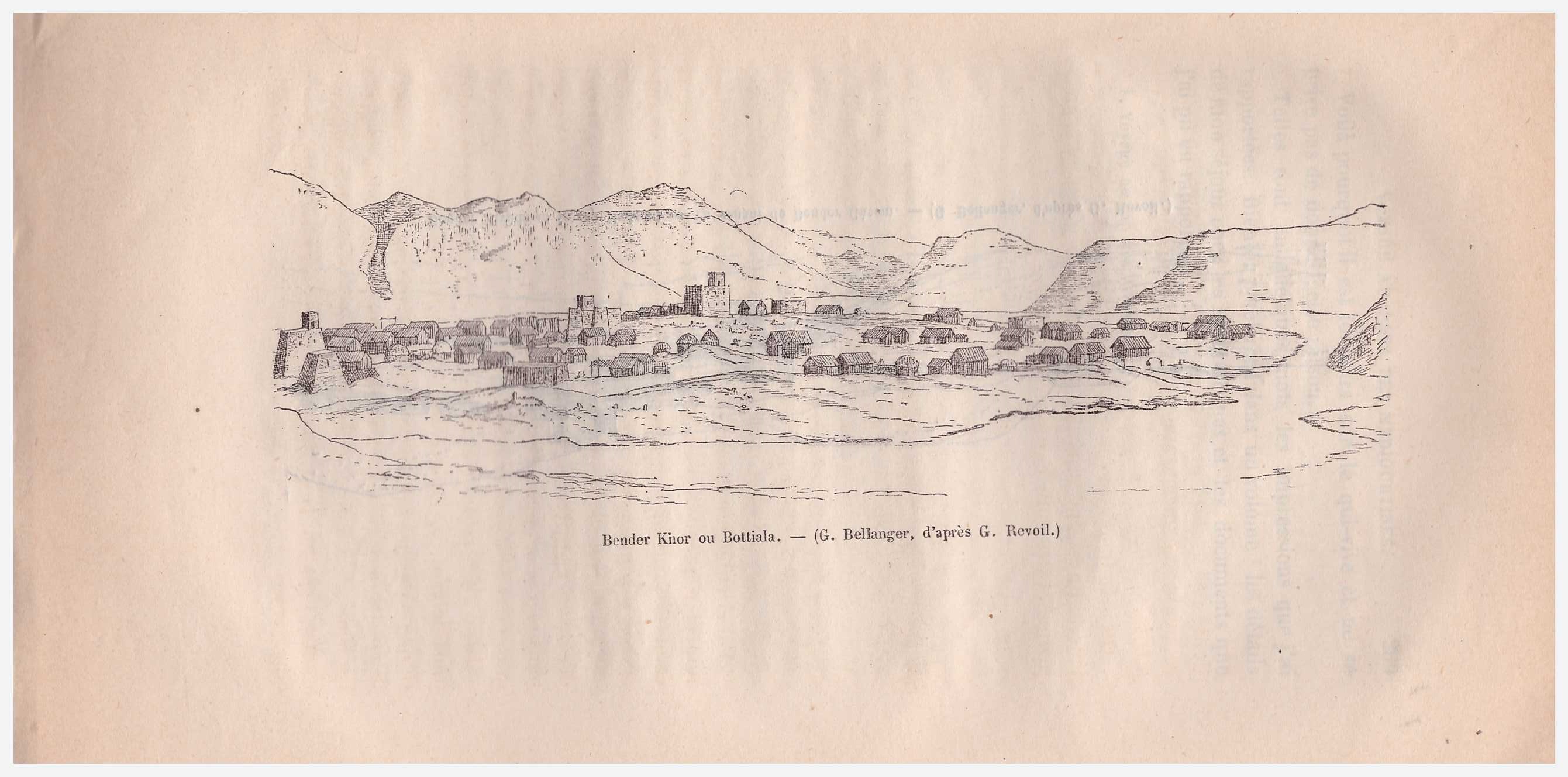 Visualizza/apri | |
| 037b_boutiala.jpg | 67.13 kB | JPEG | 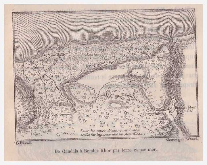 Visualizza/apri | |
| 037a_gandala1.jpg | 71.94 kB | JPEG | 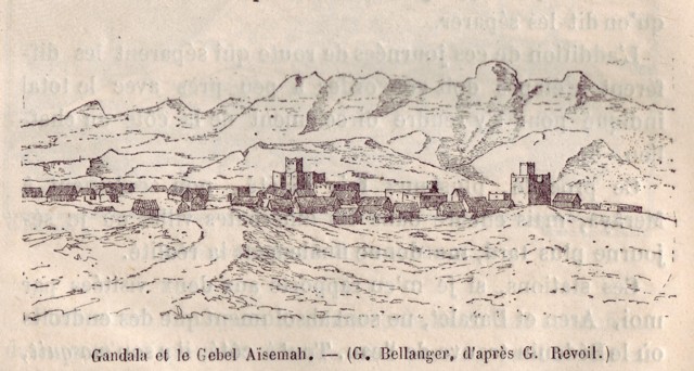 Visualizza/apri |
Page view(s)
393
Last Week
0
0
Last month
4
4
checked on 12-lug-2026
Download(s)
321
checked on 12-lug-2026

Google ScholarTM
Check
Questo documento è distribuito in accordo con Licenza Creative Commons
